Haida
Gwaii:
This triangular
archipelago known as Haida Gwaii "islands of the people"
to the Haida People is located 80 km (50miles) from the B.C. mainland.
Once known as the Queen Charlotte Islands, Haida
Gwaii is comprised of more than 150 islands, many small and uninhabited.
Graham to the north and Moresby to the south, are the largest of the islands.
To reach Haida Gwaii you may travel by air or ferry from Prince
Rupert. Direct air
service from Vancouver
is also available.
Some of
the largest trees on earth are found in the ancient temperate rain
forests of these islands. They include Sitka spruce, western hemlock,
giant red cedar and yellow cypress. Some 218 species of birds live on
these islands. The Haida, whose rich cultural traditions means living
in harmony with nature, number about 2000. The islands offer hiking,
mountain biking,
beach combing, sea
kayaking, whale watching and excellent freshwater and saltwater fishing.
Graham
Island:
Graham island is the most populated and accessible of the islands. The
BC Ferries terminus is located at Skidegate; ferries to and from Prince
Rupert and Moresby Island dock here.
Skidegate:
The Yellowhead Highway (Highway 16) continues here from the BC Ferries
terminus at Skidegate west to Queen Charlotte City and then north to Masset.
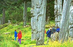
Rich in Haida culture and art, visitors may visit traditional longhouses,
totem poles and view art by the famous Haida artist, Bill Reid.
Queen
Charlotte City:
With logging and fishing as its major industries, Queen Charlotte City
was the first registered townsite on the island. Full services and accommodation
are available here. The city is located just west of Skidegate on Highway
16.
Tlell: This farming area was first settled in 1904. Nearby Naikoon Park,
miles of sand dunes and good fishing are just some of the attractions
here. Tlell is located 36 km (22 miles) from Skidegate on Highway 16.
Naikoon
Provincial Park:
Naikoon is a Haida word meaning "long nose" and indicates Rose
Spit, an ecological reserve. This long finger of land juts out into the
sea and is the northeastern tip of the island. Camping is available throughout
the park
Pesuta:
The Pesuta, is an old wooden log barge that ran ashore in a storm in 1928.
To reach this site hike 5km (3miles) through the forest and along the
beach.
Tow
Hill:
Take the north-end access (from Masset causeway). From the parking lot
hike 15 minutes through heavy rain forests to the top of the hill. The
view to the mainland and Alaska is amazing.
From Tlell,
Hwy 16 continues northwest from the coast.
Port
Clements: Located on Masset Island, 21 km (16 miles) northwest of Tlell,
this area's main industry is logging. Port Clements was a major centre
during WWII for airplane construction.
Masset:
40km (5miles) north of Port Clements at the end of Hwy 16 is Masset. Located
on Masset Sound, this is the largest community on the Islands. The Canadian
Forces Base is a big employer and fishing is the other industry. Halibut,
salmon and crab fishing trips can be booked here. Masset is fully equipped
with accommodations.
Old
Masset:
Located just north of Masset, this is the largest Haida village in Haida
Gwaii. Visit the Ed Jones Haida Museum with Haida artifacts and information
which is located at the old schoolhouse.
Moresby
Island:
Moresby can only be reached by ferry from Graham Island, or by air from
Prince Rupert or Vancouver.
Sandspit: This village is the Moresby Island terminus for ferries from
Skidegate and also has the main airport for the islands. Sandspit is fully
equipped to meet traveler's needs.
Before you
travel any logging roads on North Moresby, check with local logging concerns..
Gray
Bay:
21km (13mi) southeast of Sandspit this is a very quiet campsite with hard
sand and gravel beaches.
Mosquito
Lake Park:
These 11 rural campsites are 44km (27miles) southwest of Sandspit. Just
beyond is the Pallent Creek Hatchery.
Moresby
Camp:
To visit Cumshewa Inlet and the Moresby Islands launch your boat 2 km
(1 mile) past the hatchery.
South
Moresby/Gwaii Haanas: Officially declared a reserve in July 1988, the Gwaii Haanas
National Park Reserve encompasses over 15 percent of Haida Gwaii. Access
to this beautiful wilderness and the abandoned Haida villages found there
is possible by air or boat. Tours are available or register with Parks
Canada or the Haida Gwaii Watchmen office or base camp.
Anthony
Island:
Anthony Island
was first inhabited by the ancient Kunghit Haida until massacres by fur
traders and a small pox outbreak. Ninstints is located on the island and
was declared a UNESCO world cultural heritage site in 1981. Permission
to visit the island is available through the Parks Branch or the Haida
Gwaii Watchmen in Skidegate.
After leaving
Haida Gwaii and the Misty Isles, continue inland to the Stewart-Cassiar
Highway which connects to the Yellowhead Highway 16 and the Alaska Highway.
The following BC Adventure members would like to serve you:
Queen Charlotte Lodge: For those seeking the ultimate sport fishing adventure, the waters of the Queen Charlotte Islands and Naden Harbour are legendary for an abundance of Chinook & Coho – plus Halibut, Lingcod, and groundfish! We pride ourselves in comfortable lodging, friendly ... more